Lets take a moment to pause and reflect on the remarkable winter that has transpired. Has it really been as deep as I think it has been? Why has this winter been so fruitful for the interior West? What's all this crap I hear about El Nino and La Nina? Let's try and put some numbers to what the heck is going on.
 |
| Looking out over the expanse of the Snake Rivers |
First off has it really been good? Let's look at some SNOTEL data to settle that score. Below is a plot of the current SNOTEL snow water equivalent (SWE from here on out) and precipitation for Grand Targhee (elevation 9260 ft).

We can see that the Ghee is currently at 125% of the median SWE value for this date, sitting at about 31 inches of water. However, the highest median value occurs in early May, and that is about 46.4 inches, so we still have a ways to go. It's not like it can just stop snowing and the upper elevations will be fine, but then again it's early February and we are sitting in a good spot. As far as snowfall goes, currently the SNOTEL site has had around 337 inches so our average SWE per storm has been in that 8-10% range, which is pretty typical for Targhee, maybe a bit on the high side with some warmer storms and some atmospheric river events. Where things start to look more interesting is when we investigate the Phillips Bench SNOTEL site (elevation 8200 ft) on the east side of Teton Pass.

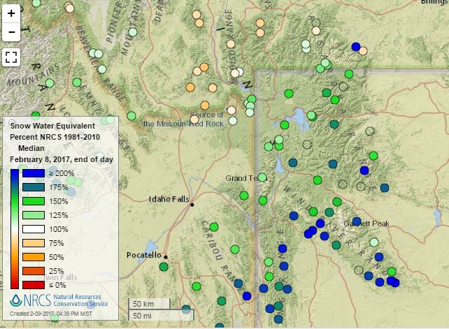
At Phillips Bench we are sitting at 24.4 inches which is 144% percent of the median and only an inch less that the max value for the median which occurs in mid April. So theoretically, if it stopped snowing from now until April and the snow pack didn't melt, we'd be fine. That's pretty ridiculous when we realize that we are only through with the first week of February. Let's look at the Greater Yellowstone ecosystem and see where everyone sits.
So we can see that with the exception of SW Montana, pretty much everyone is at or above average. Some truly huge numbers are showing up in the Salt River Range and the southern Wind River Range, areas that are heavily favored during periods of strong SW flow that have occurred during the atmospheric river events. The upper Green River basin is looking absolutely stacked for snowfall right now, with many sites recording far greater SWE values than the maximum median value that usually occurs in April or May.
Now even though SWE is almost all that matters for water supply, many skiers just care about inches of snow. We already discussed that Targhee SNOTEL was at 337, but the Chief Joseph plot is only at 325. Over at JHMR, the Raymer plot is at 371 inches and Rendevous summit is at an astounding 411 inches (as of Feb 9th). Now what is average? Well that is hard to say because the ski areas have a way of bull shitting their numbers, but we can say that it is probably close to (or greater than) 480" at 9000 ft at Targhee and closer to 420" at 9000 ft on the JHMR side. Many people have become used to the fact that Targhee gets more snow than Jackson, but this year that is simply not the case. To be fair, the Rendevous plot is at 9580' and the Raymer plot is at 9300', compared to 8800' at Chief Joe, but I don't think a difference of 800 ft can explain 85" of snow. Once again it has to due with the storms we have been getting, a lot of strong SW flow aloft with warmer temperatures. These kinds of storms can completely spill over the Teton crest before the air cools enough to produce precipitation. Since the Tetons are so narrow, the dynamics that drive leeward precipitation are quite a bit different than a range like the Sierra, where we would expect a rain shadow on the leeward side of the mountains.
 |
| No soup for you Vail! |
Overall I think that it's fair to say that the entire western lower 48 is having a good winter. Places that are a little below average include western Montana, the Idaho Panhandle, and even a few places in western Washington state. Other than that, the Wasatch and Unitas are getting hammered, the Sierras annihilated, the central Cascades pummeled, and even Callmeradbro is sitting around 130% of median SWE. I am still holding out hope for my beloved Bridger Bowl, because all it would take is one 3 footer to put them right back on track.
 |
| With great snow comes great responsibility. I remotely triggered this guy from the ridge line on the left. |
Why are we getting so many storms? Well the rather simple answer to this question is that the jet stream has been in a favorable position for the last two months or so, and the position of the jet is the main driving factor for the storm tracks we see in the inter-mountain west. Whether storms are generated in the western pacific by Kamchatka, or up near the Aleutian islands, or from atmospheric river events (more on this later) they need to be directed our way via the jet stream. Most meteorologists look at the 300 mb pressure level to see what the jet is up to, and a well organized, strong jet that is positioned around the 43rd parallel is just what we need to replenish the snake river plain convergence zone with moisture.
 |
| Current 300mb map used to initialize the NAM |
Why has the jet been in such a favorable position so far this winter (excluding November)? Now this is a much harder question to answer and I really don't know, however no one really could have predicted this. In a basic sense the jet arises due to an energy imbalance. The equatorial regions have a surplus of energy (sunlight) and the poles have an energy deficit throughout the winter months. Thus there is a natural tendency for the atmosphere to want to transport energy pole-ward. The jet stream and storms (low pressure systems) serve the purpose of transporting both energy and momentum pole-ward. If we think very basically about the hot high pressure equator trying to transport energy and momentum via winds towards the cold, low pressure poles and then we take the Coriolis effect into account (conservation of angular momentum) we could conceive of how a westerly jet stream could come about. Now of course this is overly simplistic and could therefore be construed as bull shit, but hang with me. All I'm try to say is that there are winters where the jet is too far to the north of the Tetons (too little energy difference) and winters where the jet can split up or go south of the Tetons (too much energy difference). In December, January, and so far in early February we've got that energy difference just freakin' right. Remember too that the jet is constantly changing in magnitude and direction, so I am mostly speaking in a time-averaged sense. So I don't know if it was the warm summer at the mid latitudes, the fact that an anomalous ridge blasted the heat throughout all November, or the fact that a mild la Nina (really a la ninita or something smaller that a tiny la nina) cooled the eastern pacific from the monster el Nino last winter, but it was probably all or none of these factors that led to our current situation.
 |
| Massive propagation on a S facing slope. |
What's all this crap I'm hearing about atmospheric rivers? Well an atmospheric river is band of moisture that extends from the tropics to western North America. These events can account for over 70% of the total precipitation areas like the Sierras, which sorta explains why it snows like 3 times a year there but dumps 10 feet each time. These events bring "alien-like" air to the mid-latitudes, meaning the air carries a relatively warm temperature and ridiculous amounts of water vapor. Thus these systems are not necessarily baroclinic low pressure systems, and orographics play a dominant role in who gets the precipitation. Atmospheric river events happen each year, but off the top of my head I can think of at least four major events this season which is pretty high for early February. If an atmospheric river can penetrate into the inter-mountain west, the snake river plane can help channel the flow, dropping copious amounts of SWE in the Snake River Range, the Winds, the Gos Ventre's, and areas of the Wasatch (after California, Oregon and southern Washington get slammed). These events are a large reason as to why this winter has been so ridiculous
 |
| Integrated water vapor transport, reeeaaal moist right now |
So whats in store for the rest of the winter? Who the fuck knows. After the weekend the GFS is predicting a rather large ridge to set up over the western US. This ridge looks kinda similar to what transpired in November. However, the GFS predicts that the ridge should break down by around the 20th. If that's the case, then we could use a week long break before the snowpocalypse continues, but I don't want to see a month of dry weather. We will just have to see. Right now Teton pass, snake river canyon, and Hoback canyon are all closed due to avalanches. JHMR has been without power since Tuesday due to winds, and they aren't planning to open until Monday the 13th. The god damn roof over Sears collapsed in Jackson due to too much snow. So the week long break should be nice if the rain and warming temps don't flood the place too much. My advice is to take advantage of this winter, because we probably won't see one like it for 10 or more years if this crap continues.

Also I should note that my favorite log ride on Teton pass collapsed due to snowfall, and I've been riding that thing since at least 2010.
 |
| A whole lotta this crap has been going on this season... |